天然地震
地震数据中Channel描述
| Channel | Description |
|---|---|
| EHZ/EHN/EHE | Short Period 100 sps |
| BHZ/BHN/BHE | Broad Band 20 sps |
| LHZ/LHN/LHE | Long Period 1 sps |
| VHZ/VHN/VHE | Very Long Period 0.1 sps |
| BCI | Broad Band Calibration Signal |
| ECI | Short Period Cal |
| LOG | Console Log |
| ACE | Administrative Clock Error |
| LCQ | 1hz Clock Quality |
| OCF | Opaque Configuration File |
天然地震数据处理包obspy教程
obspy教程,以Tohoku-Oki:2011-03-11日本大地震为例
台站数据访问方法
1 | import obspy |
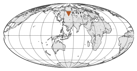
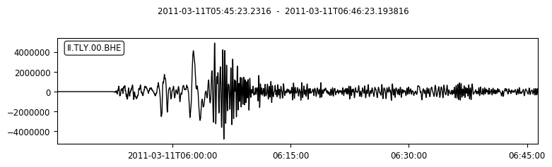
以上代码中,cat、inv和st的plot方法分别绘制了地震事件、台站位置信息以及波形信息。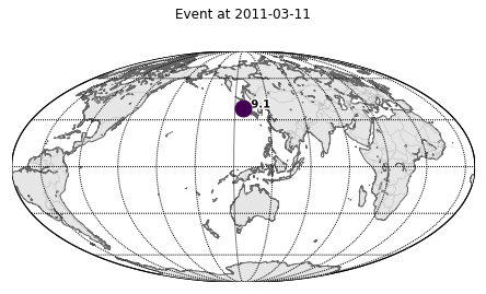
利用MassDownloader下载数据
台站数据下载教程(obspy.clients.fdsn.mass_downloader)
1 | import obspy |
以上代码会将时间origin_time之前5分钟、之后1小时以内,区域范围为圆形的domain(以经纬度以及环形区域为限定)的数据下载到当前目录下的./waveform文件夹中,台站数据则存储在./stations中。
本地文件读取(以.mseed为例)及显示
演示三通道数据读取与显示1
2
3
4
5
6
7
8
9import obspy
from obspy.core import read
path = r'./waveforms/'
tc = read(path+'AG.HHAR.00.HHE__20110311T054232Z__20110311T064732Z.mseed')
tc += read(path+'AG.HHAR.00.HHN__20110311T054232Z__20110311T064732Z.mseed')
tc += read(path+'AG.HHAR.00.HHZ__20110311T054232Z__20110311T064732Z.mseed')
print(tc)
# Save plot to file
tc.plot(outfile='test.png')
输出:1
2
3
4
5
6
73 Trace(s) in Stream:
AG.HHAR.00.HHE | 2011-03-11T05:42:32.000000Z - 2011-03-11T06:47:32.000000Z | 100.0 Hz, 390001 samples
AG.HHAR.00.HHN | 2011-03-11T05:42:32.000000Z - 2011-03-11T06:47:32.000000Z | 100.0 Hz, 390001 samples
AG.HHAR.00.HHZ | 2011-03-11T05:42:32.000000Z - 2011-03-11T06:47:32.000000Z | 100.0 Hz, 390001 samples
"""
当流中的Traces过多时,print(stream)只会打印部分Trace,此时可通过print(stream.__str__(extended=True))来打印流中的所有Trace。
"""
基础绘图:1
2# Basic plotting
tc.plot()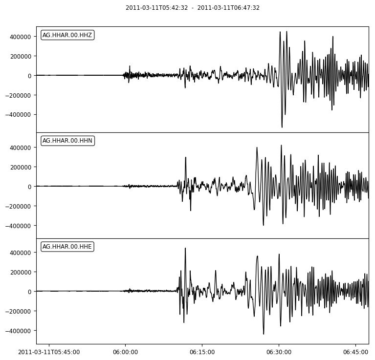
自定义绘图:1
2
3
4
5# Customized Plots
dt = tc[0].stats.starttime
tc.plot(color='red', number_of_ticks=7,
tick_rotation=5, tick_format='%I:%M %p',
starttime=dt + 60*60, endtime=dt + 60*60 + 120)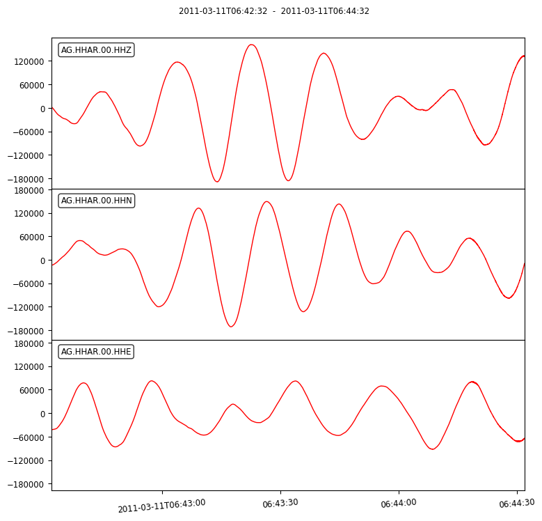
使用Matplotlib进行自定义绘图:1
2
3
4
5
6
7
8# Custom Plotting using Matplotlib
import matplotlib.pyplot as plt
fig = plt.figure()
ax = fig.add_subplot(1, 1, 1)
ax.plot(tc[0].times("matplotlib"), tc[0].data, "b-")
ax.xaxis_date()
fig.autofmt_xdate()
plt.show()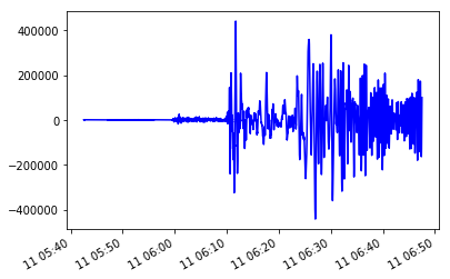
按小时绘制一整天道记录(文件中必须含有整天的数据):1
2tc = read(path+'BW.ALTM..EHE__20120101T000000Z__20120102T000000Z.mseed')
tc.plot(type='dayplot')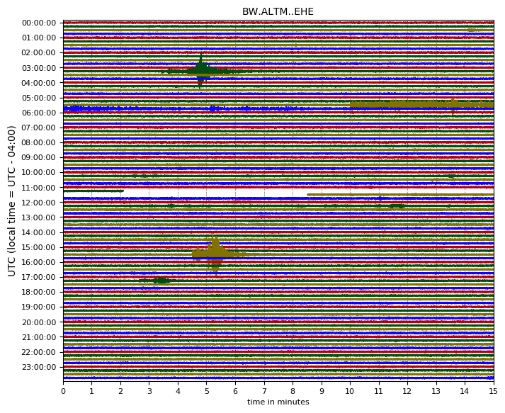
plot中显示地震事件1
2
3
4
5
6
7from obspy import read
st = read("./BW.ALTM..EHE__20121207T000000Z__20121208T000000Z.mseed")
#st.filter("lowpass", freq=0.1, corners=2)
st.plot(type="dayplot", interval=60, right_vertical_labels=False,
vertical_scaling_range=5e3, one_tick_per_line=True,
color=['k', 'r', 'b', 'g'], show_y_UTC_label=False,
events={'min_magnitude': 6.5})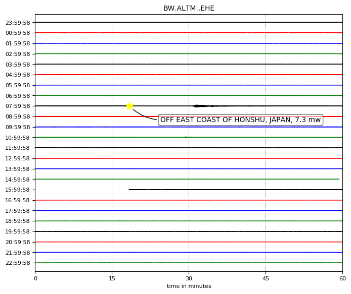
地震台站Google地图及信息查询
Network Codes
地震网络编码查询:https://www.fdsn.org/networks/?initial=1
Global Seismograph Network - IRIS/IDA
FDSN Network Information
| FDSN code | II | Network name | Global Seismograph Network - IRIS/IDA (GSN) |
|---|---|---|---|
| Start year | 1986 | Operated by | Scripps Institution of Oceanography (SIO) |
| End year | - | Deployment region | Global |
| Network Website | http://ida.ucsd.edu/ |
Stations in this Network
| Station Code | Station Name | Latitude | Longitude | Data Center(s) |
|---|---|---|---|---|
| AAK | Ala Archa, Kyrgyzstan | 42.6375 | 74.4942 | IRISDMC |
| ABKT | Alibek, Turkmenistan | 37.9304 | 58.1189 | IRISDMC |
| ABPO | Ambohimpanompo, Madagascar | -19.018 | 47.229 | IRISDMC |
| ALE | Alert, NU, Canada | 82.5033 | -62.35 | IRISDMC |
| ARTI | Arti, Russia | 56.3879 | 58.3849 | IRISDMC |
| ARU | Arti, Russia | 56.4302 | 58.5625 | IRISDMC |
| ASCN | Butt Crater, Ascension Island | -7.9327 | -14.3601 | IRISDMC |
| BFO | Black Forest Observatory, Schiltach, Germany | 48.3301 | 8.3296 | IRISDMC |
| BORG | Borgarfjordur, Asbjarnarstadir, Iceland | 64.7474 | -21.3268 | IRISDMC |
| BORK | Burabay, Kazakhstan | 53.0461 | 70.3184 | IRISDMC |
| BRVK | Borovoye, Kazakhstan | 53.0581 | 70.2828 | IRISDMC |
| CMLA | Cha de Macela, Sao Miguel Island, Azores | 37.7637 | -25.5243 | IRISDMC |
| COCO | West Island, Cocos (Keeling) Islands | -12.1901 | 96.8349 | IRISDMC |
| DGAR | Diego Garcia, Chagos Islands, Indian Ocean | -7.4121 | 72.4525 | IRISDMC |
| EFI | Mount Kent, East Falkland Island | -51.6753 | -58.0637 | IRISDMC |
| ERM | Erimo, Hokkaido Island, Japan | 42.015 | 143.1572 | IRISDMC |
| ESK | Eskdalemuir, Scotland, UK | 55.3167 | -3.205 | IRISDMC |
| FFC | Flin Flon, Canada | 54.725 | -101.9783 | IRISDMC |
| GAR | Garm, Tajikistan | 39.0052 | 70.3328 | IRISDMC |
| HOPE | Hope Point, South Georgia Island | -54.2836 | -36.4879 | IRISDMC |
| IASL | Albuquerque Seismological Laboratory, N.Mex. | 34.946201 | -106.456703 | IRISDMC |
| IBFO | Black Forest Observatory, Schiltach, Germany | 48.331902 | 8.3311 | IRISDMC |
| JTS | Las Juntas de Abangares, Costa Rica | 10.2908 | -84.9525 | IRISDMC |
| KAPI | Kappang, Sulawesi, Indonesia | -5.0142 | 119.7517 | IRISDMC |
| KDAK | Kodiak Island, Alaska, USA | 57.7828 | -152.5835 | IRISDMC |
| KIV | Kislovodsk, Russia | 43.9562 | 42.6888 | IRISDMC |
| KURK | Kurchatov, Kazakhstan | 50.7154 | 78.6202 | IRISDMC |
| KWAJ | Kwajalein Atoll, Pacific Ocean | 8.8019 | 167.613 | IRISDMC |
| KWJN | Gagan, Kwajalein Atoll, Marshall Islands | 9.2873 | 167.5369 | IRISDMC |
| LVZ | Lovozero, Russia | 67.8979 | 34.6514 | IRISDMC |
| MBAR | Mbarara, Uganda | -0.6019 | 30.7382 | IRISDMC |
| MSEY | Mahe, Seychelles | -4.6737 | 55.4792 | IRISDMC |
| MSVF | Monasavu, Fiji | -17.7448 | 178.0528 | IRISDMC |
| NIL | Nilore, Pakistan | 33.6506 | 73.2686 | IRISDMC |
| NNA | Nana, Peru | -11.9875 | -76.8422 | IRISDMC |
| NRIL | Norilsk, Russia | 69.5049 | 88.4414 | IRISDMC |
| NVS | Novosibirsk, Russia | 54.8404 | 83.2346 | IRISDMC |
| OBN | Obninsk, Russia | 55.1146 | 36.5674 | IRISDMC |
| PALK | Pallekele, Sri Lanka | 7.2728 | 80.7022 | IRISDMC |
| PFO | Pinon Flat, California, USA | 33.6092 | -116.4553 | IRISDMC |
| RAYN | Ar Rayn, Saudi Arabia | 23.5225 | 45.5032 | IRISDMC |
| RPN | Rapanui, Easter Island, Chile | -27.1267 | -109.3344 | IRISDMC |
| SACV | Santiago Island, Cape Verde | 14.9702 | -23.6085 | IRISDMC |
| SHEL | Horse Pasture, St. Helena Island | -15.9594 | -5.7455 | IRISDMC |
| SIMI | Simiganj, Tajikistan | 38.6585 | 69.0083 | IRISDMC |
| SUR | Sutherland, South Africa | -32.3797 | 20.8117 | IRISDMC |
| TAU | Hobart, Tasmania, Australia | -42.9099 | 147.3204 | IRISDMC |
| TLY | Talaya, Russia | 51.6807 | 103.6438 | IRISDMC |
| UOSS | Univ. of Sharjah, Sharjah, United Arab Emirates | 24.9453 | 56.2042 | IRISDMC |
| WRAB | Tennant Creek, NT, Australia | -19.9336 | 134.36 | IRISDMC |
| XBFO | Black Forest Observatory, Schiltach, Germany | 48.3301 | 8.3296 | IRISDMC |
| XPF | Pinon Flat, California, USA | 33.6092 | -116.4533 | IRISDMC |
| XPFO | Pinon Flat, California, USA | 33.6107 | -116.4555 | IRISDMC |